

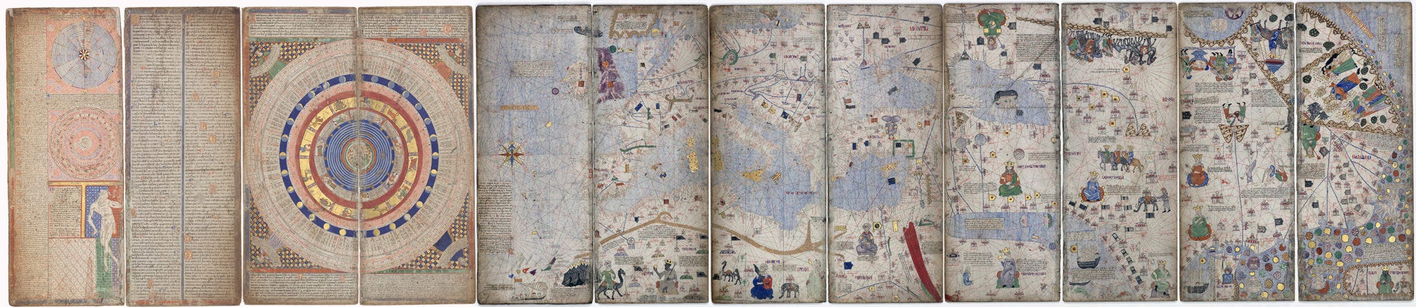
The Catalan Atlas
Manūscriptum: Edition II

Welcome to Cosmographia. What follows is part of our Manūscriptum series, where we take a look at some of history’s most beautiful documents. For the full map of Cosmographia posts, see here.
There are few maps in the history of cosmography that are as momentous, or as beautiful, as the Catalan Atlas.
Produced on the island of Majorca — then part of the Crown of Aragon — somewhere between the years of 1370-1380 AD, the consensus among historians is that the atlas was probably the work of a renowned Jewish book illuminator and master mapmaker called Elisha ben Abraham Cresques, possibly with the help of his son, Jehuda.
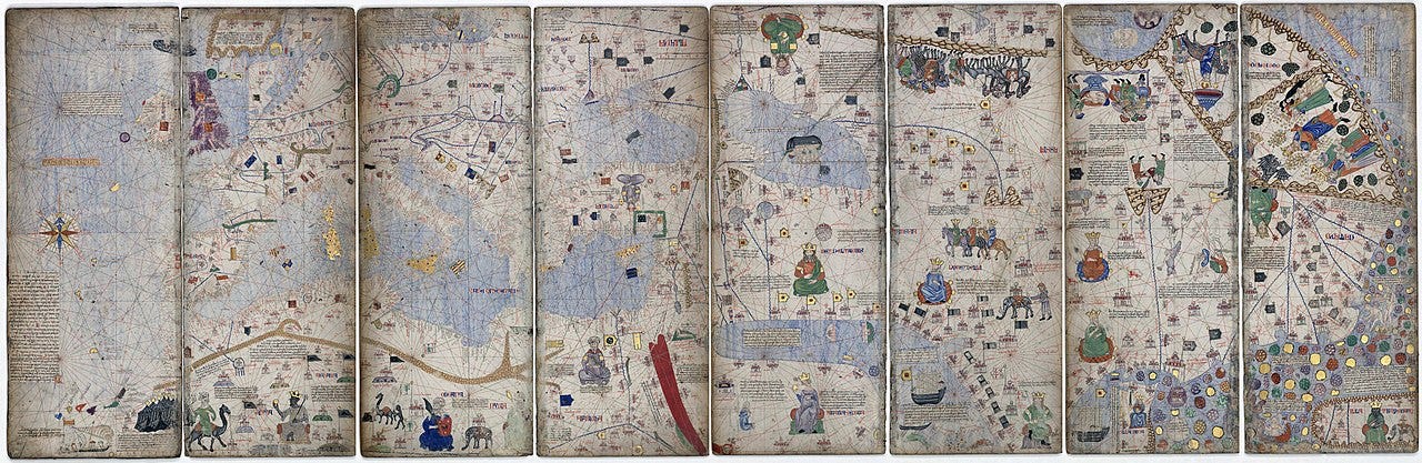
Measuring nearly ten feet wide and divided into six parchment leaves, the atlas combines various cartographic techniques and extensive commentary to create a comprehensive visual encyclopaedia of the known world. Featuring cartoonishly-drawn kings, mythical baddies, and terrifying beasties, the stunning chart gives us a fascinating glimpse into how medieval Europe once saw the world. Let’s have a look at each section in turn.

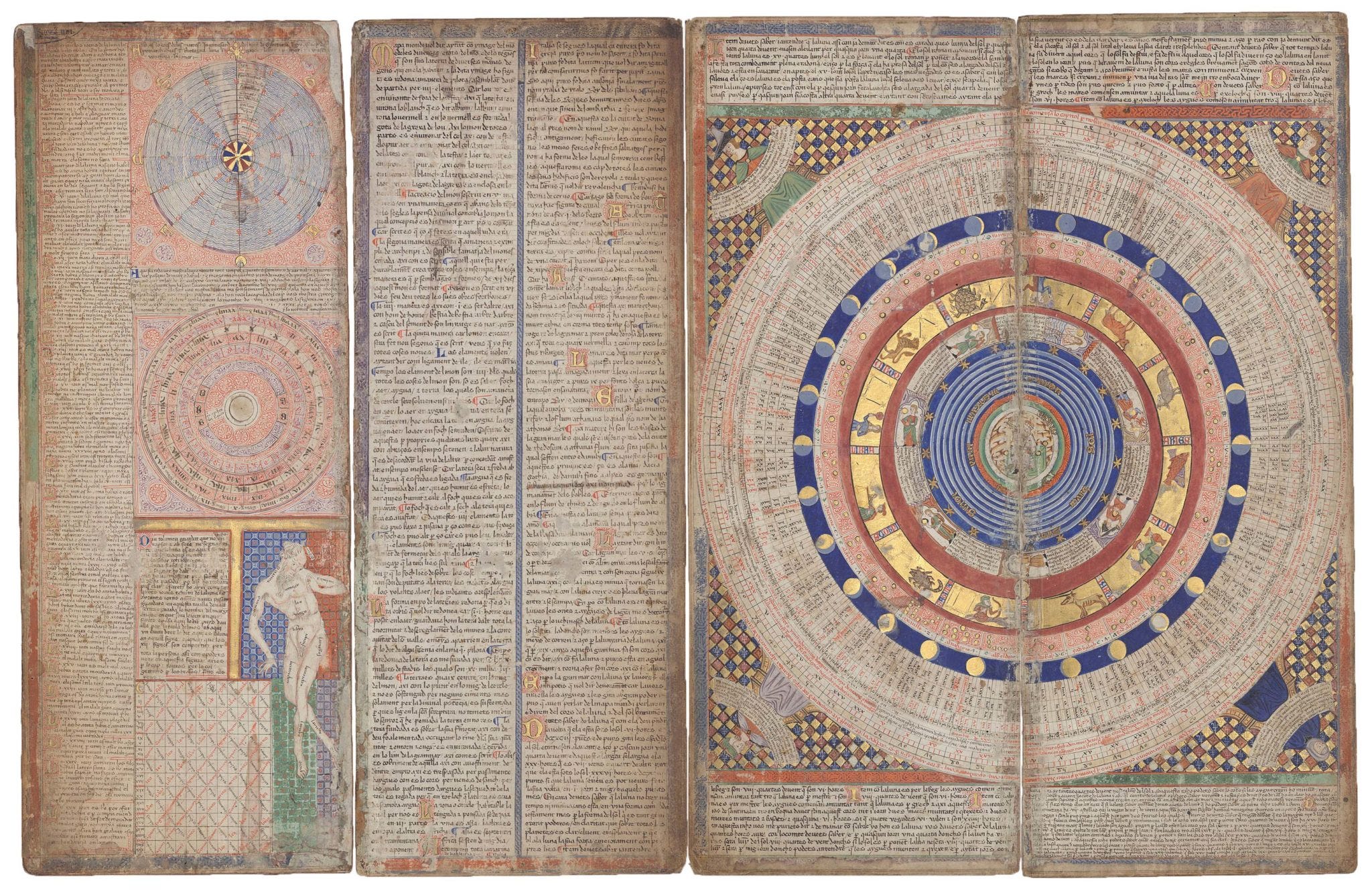
The first two panels of the Catalan Atlas contain texts and diagrams showing the 14th century understanding of the cosmos, turning what would be a work of cartography into a cosmographic enterprise. Containing charts for determining days, tides, holiday dates, and even a little sketch of the human anatomy, these leaves were less for practical use than they were present an image of an ordered cosmos.
However, in a rather daring twist, leaf two has at its centre not the traditional depiction of God the Creator, but instead a drawing of a scholar with a quadrant — perhaps a hint from Cresques as to where his true allegiance lay. This figure is surrounded by colourful circles, which, from in to out, are: the celestial spheres of the Ptolemaic model of the heavens, phases of the moon, 12 signs of the zodiac, and various calendars.

Given the map’s ambitious scope and use of expensive materials, the Catalan Atlas was almost certainly a commission from the King Peter IV of Aragon, probably as a gift for the French King Charles V. (The map remains in the collection of Bibliothèque nationale de France to this day.)
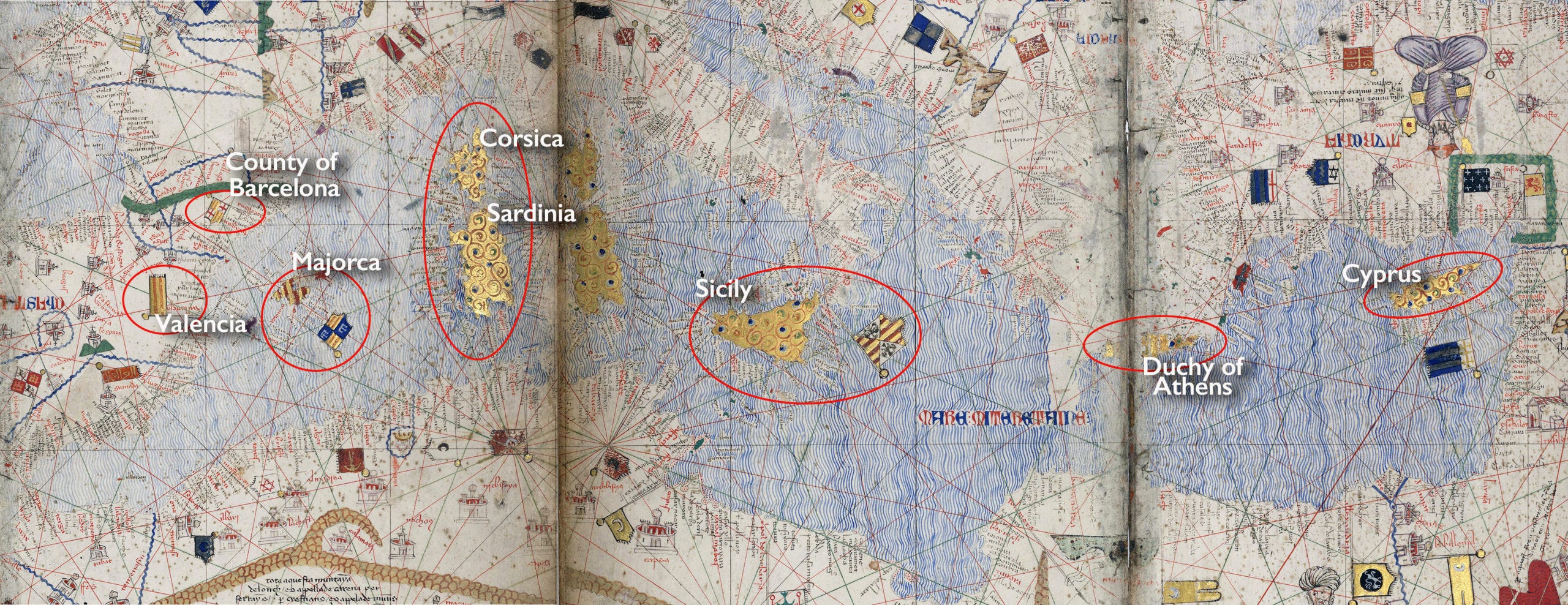
Given Cresques’ patron, it’s no surprise that the might of the Crown of Aragon is emphasised on the map, with its territories marked out in gold. The Aragonese had expanded their control over the seas since the mid-13th century, and by the 14th, they ruled much of the central and western Mediterranean, including parts of Spain, Italy, Greece, Asia Minor, and islands like Majorca, Sicily, Minorca, Ibiza, and Sardinia. These territories were not a single polity, but instead constituted a composite monarchy of various kingdoms, united only by the having the same king.

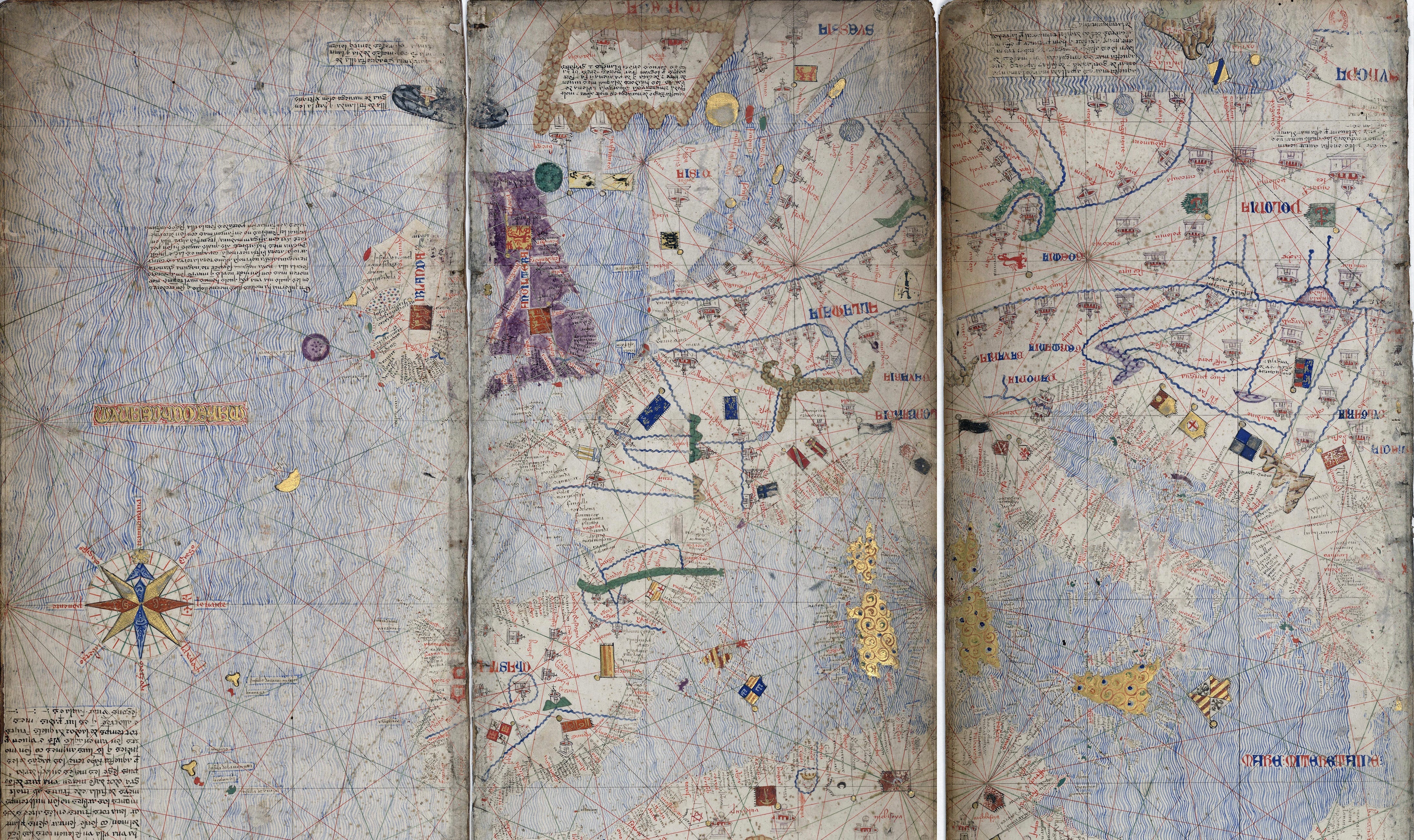
Zooming out to look at Europe as a whole, a few intriguing details catch the eye. Firstly, the island of Great Britain is inexplicably coloured purple. Given that England, its largest kingdom, was a bit of a backwater at this time, far less wealthy than either Aragon or France, it’s strange that it would be painted in a colour that traditionally represented power, royalty, and prestige.1 It’s unlikely to be because of any special friendship between the Crown of Aragon and the Kingdom of England; this map came over a century before Henry VIII married Catherine of Aragon, and there was little diplomacy of importance before then. However, Cresques has coloured many of the islands on the map different colours — Iceland to the north of Scotland is coloured blue, for instance — so perhaps Britain is purple just by chance. Ireland appears to be covered in a now much-faded brown wash, so maybe the two colours were intended to differentiate between the two parts of the British Isles (Ireland was subject to the English crown at the time).
The Catalan Atlas introduced the motif of displaying circular islands as buttons (I have no idea why), a trope that continued on other maps for a time. The purple button to Ireland’s southwest is the mythical island of Brazil (not to be confused with the country, founded much later and named via a different route), while the turquoise one off the northeast coast of Scotland is the mythical island of Thule.
Mainland Europe is dominated by charming ribbon-rivers, rather ugly brown or green smushes for mountains, and many identical little cities dotting the landscape. The lack of defined borders between the various kingdoms perhaps indicates the more fluid sense of place during the Middle Ages — all we get instead are little royal banners dotted around the continent. Also interesting: the compass rose out in the Atlantic is the first ever instance of an ornate compass in cartographic history. So that’s nice.

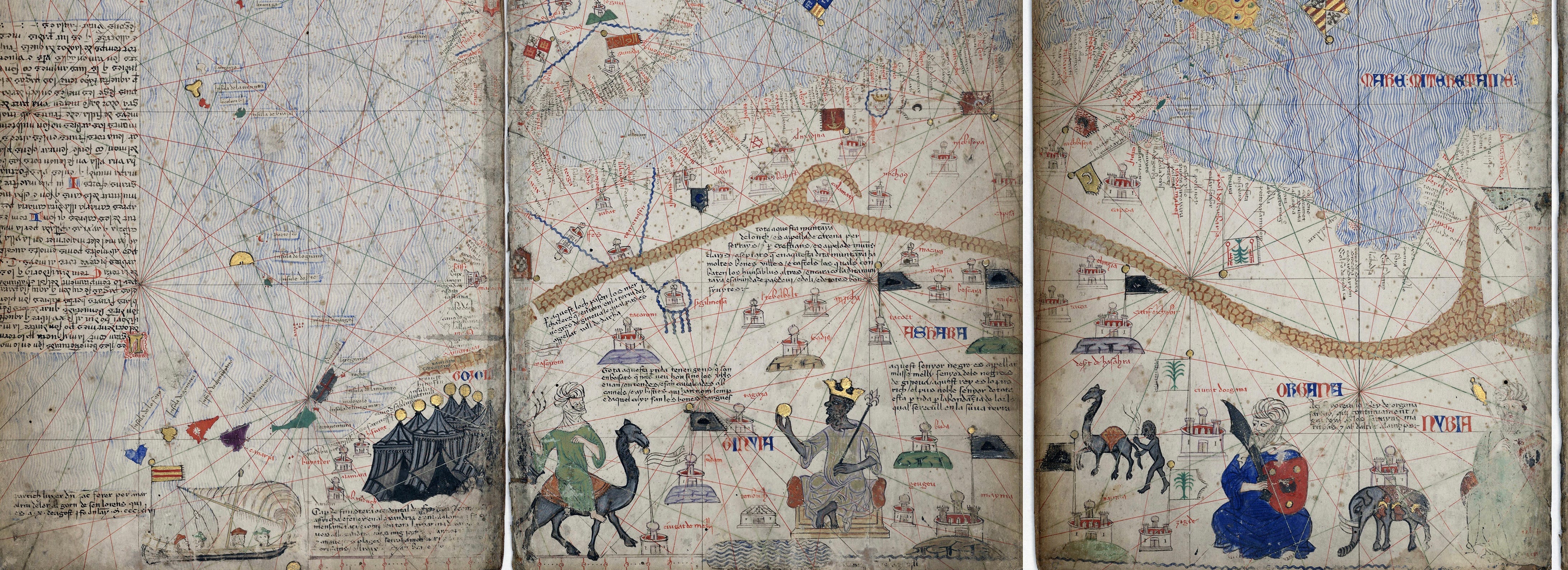
Moving southwards to North Africa, we are treated to a plethora of delightful sketches. Sailing down the west coast of the continent is the Majorcan explorer Jaume Ferrer. Almost everything we know about this sailor in contained within the inscription on this map: “The ship of Jaume Ferrer departed for the River of Gold on the 10th of August of 1350, the feast of St. Lawrence!” The River of Gold was an old legend that drew many a European adventurer south, dreaming of riches. His position on the map suggests he may have sailed past Cape Bojador, which in its original Arabic meant “Father of Danger,” so named for the many who died trying to round its treacherous waters. No ones knows if Ferrer ever returned.
Just north of Ferrer’s ship lies a chain of multi-coloured islands. These are labelled as the Fortunate Isles, a group of semi-legendary islands that were sometimes treated as a real geographical location, sometimes as a part of the Underworld, and sometimes both simultaneously. In Greek mythology, these islands were part of Elysium — an afterlife realm reserved for the heroes of myth like Achilles, Ajax, and Harmonia. In various legends, the Isles of Blessed, as they were sometimes known, were said to lie out west of the Mediterranean, somewhere off the coast of Africa. By the 14th century, it was common practice for cartographers to equate the Fortunate Isles with the newly rediscovered Canary Islands off the coast of Morocco.
Moving inland, we can see a camel-riding nomad and his black tents. East of him, we see perhaps the most famous image from the Catalan Atlas: that of Mansa Musa, possibly the richest man who ever lived. Around 50 years before the map’s production, Musa had embarked on his now-legendary hajj pilgrimage to Mecca. It is said he brought so much gold in his caravan train that when he arrived in Cairo the value of gold depreciated for the next ten years, crippling the local economy.
Cresques’ depiction of the great Mansa of the Mali Empire in all his golden glory breaks with the European cartographic tradition of showing Africa as a peripheral blank space. Instead, Musa is given equal status to other monarchs found elsewhere on the map, and his empire is shown as a vibrant economic centre. Having said that, Cresques rather lets himself down with his sketch of a black camel trader to the east of Musa. The man is portrayed as rather primitive. Such were the times.

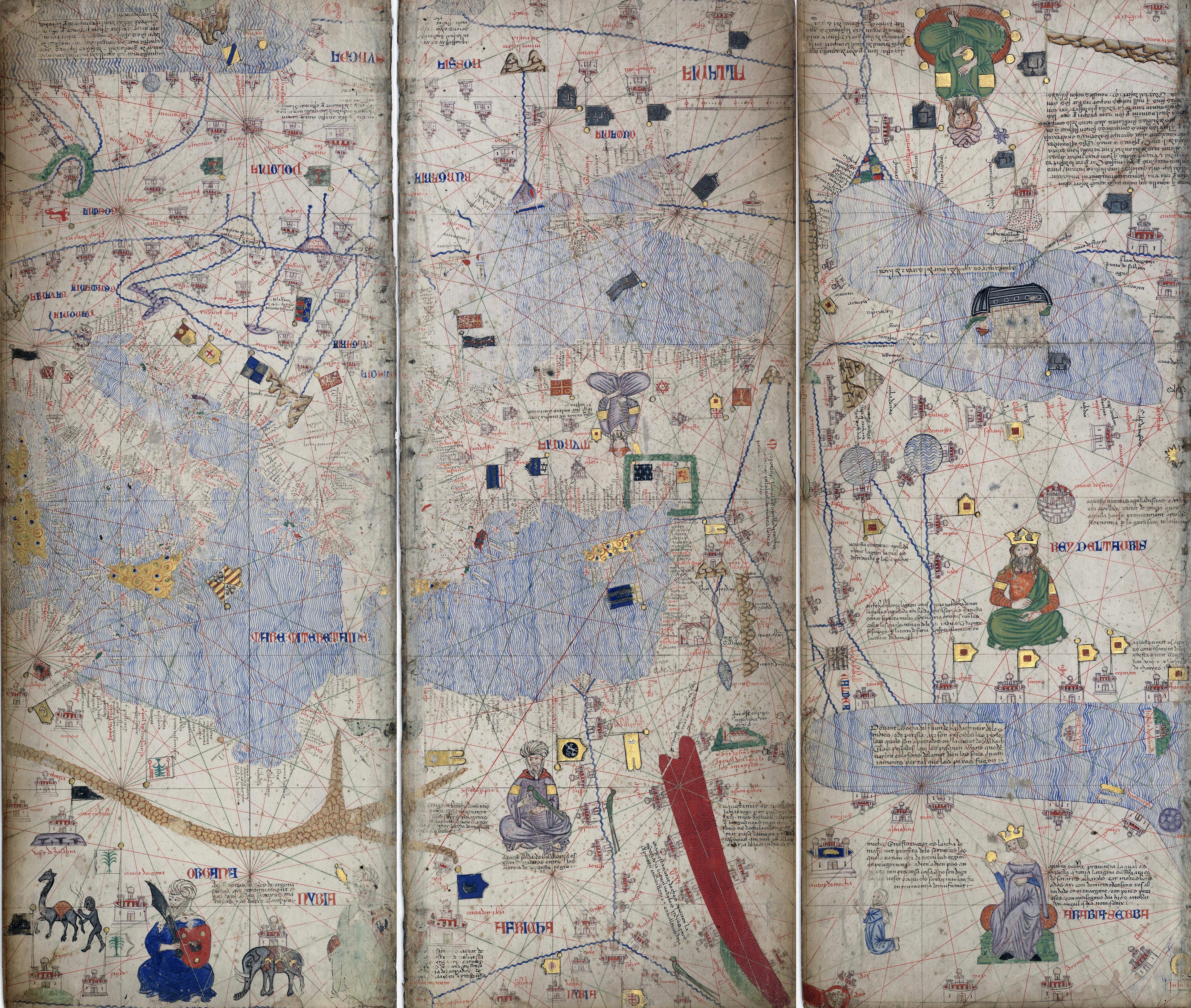
Moving now to the middle leaves of the atlas, we see more seated rulers, two of whom appear upside-down. The map was designed to be displayed in the centre of a table, so no matter where a viewer was stood, the portion of the map closest to them was oriented correctly.
This map came some 70 years before the Fall of Constantinople to the Turks, so the unnamed and upside-down Ottoman ruler sits in the middle of Anatolia. Also upside down (top right) is Jani Beg of the Golden Horde, whose empire ruled vast swathes of northeastern Europe and Central Asia. The Khan’s appearance belies the fact he was actually murdered by his own son some 30 years before this map was produced. The fellow sitting just next to the Nile holding a green parrot is possibly the Mamluk Sultan al-Ashraf Sha'ban, while Arabia is graced with the presence of the Queen of Sheba, who inexplicably appears as a white woman with blonde hair. North of her is a figure who looks suspiciously like Jesus Christ, but the label actually reads “Rey del Tauris,” indicating him as the Mongol Il-Khanate ruler.
Special shout outs to the blood-red waters of the Red Sea, the lonely vessel sailing the Caspian, and Jerusalem which is depicted differently to all the other cities on the map, appearing as a church rather than a castle.
Tantalisingly, next to the much-faded figure of the green-robed King of Nubia (in Africa, southwest of Egypt), reads the inscription, “The king of Nubia is always at war with the Christians of Nubia who are under the dominion of the emperor of Ethiopia and the land of Prester John.” Two of the cities south of the confluence of the Nile have flags that bear a resemblance to the Papal Cross, so I suspect they’re intended as an allusion to the mythical Christian king, who is perhaps lurking just off-map. Over the centuries, Prester John was thought to have been in either Ethiopia or India, where his kingdom had been isolated from the rest of Christendom by the spread of Islam.

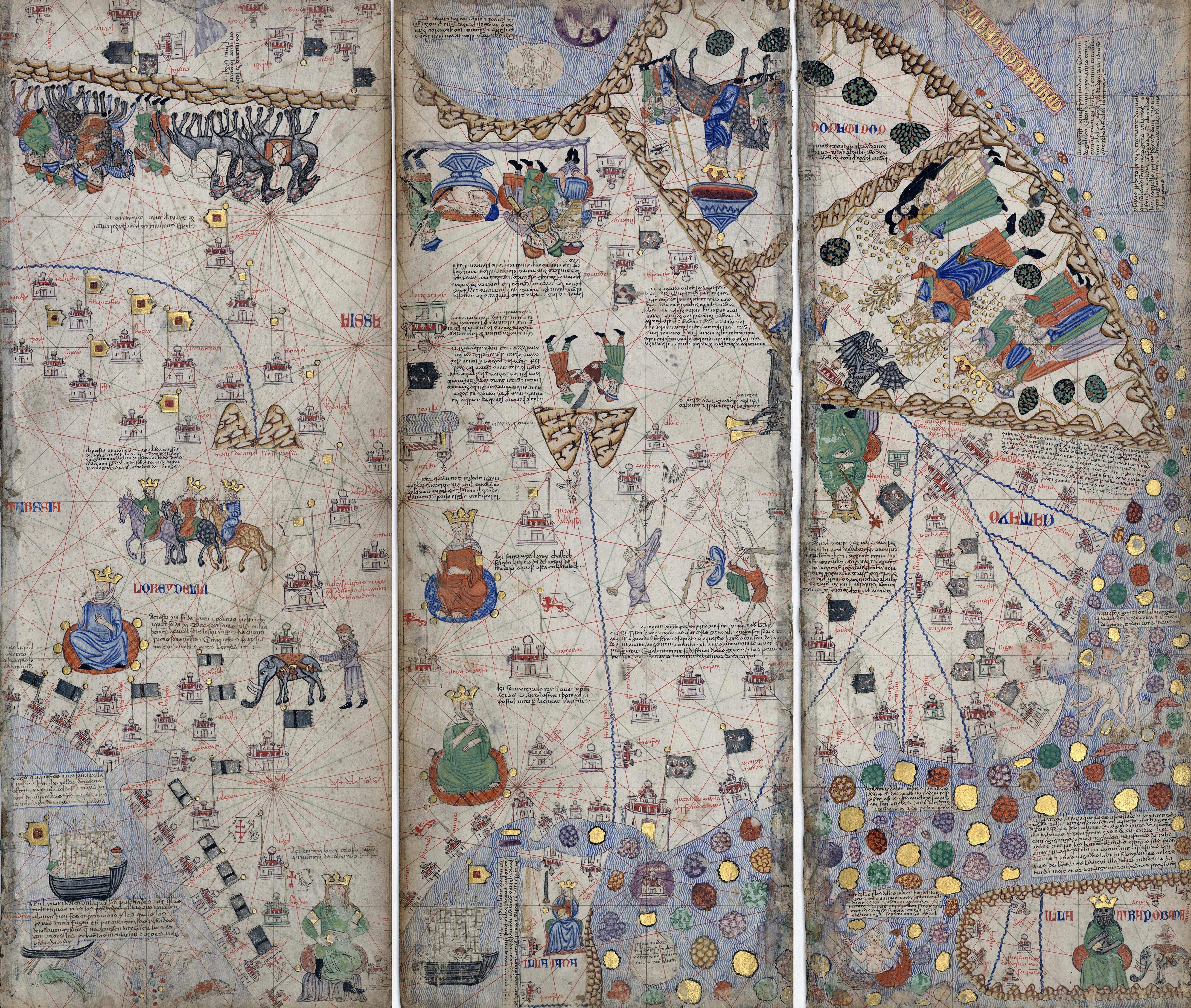
As the Catalan Atlas was the first map that incorporated the lands described by Marco Polo, Sir John Mandeville, and a few other diplomatic missions of the 13th/14th centuries, there’s a lot of detail that is surprisingly accurate. But what’s more fun are the really weird elements that start to appear as we get further and further east.
The group of riders at the top left represent Marco Polo and his entourage. South of them are: the Three Wise Men on their way to Bethlehem; the Sultan of Delhi; and, right at the bottom of the Indian subcontinent, the “King of Colombo,” who’s marked as a Christian. This is wishful extrapolation from the small community of Saint Thomas Christians who’d lived in Kerala since the 8th century. Northwest of here are two more figures: King Stephen in green, supposedly representing the Christian minorities in India;2 and, above him, in red, is the Khan Kebek, Mongol ruler of the Chagatai Khanate.
To the right of the Khan are a group of diamond hunters throwing meat at birds,3 while directly north of here are a pair of twin peaks (which seem to be a wildly misplaced, and wildly underestimated, depiction of the Himalayas) that house subterranean snakes tied in knots. Above this you’ll see a drawing of what appears to be an old man taking a bath, but is actually meant to be a dead body about to be cremated, while a band plays some music. Trace north one more time to find two button-islands that seem to hide giant birds, possibly rocs — giant mythical birds believed to carry men away in their claws.
But the best of all is still yet to come.

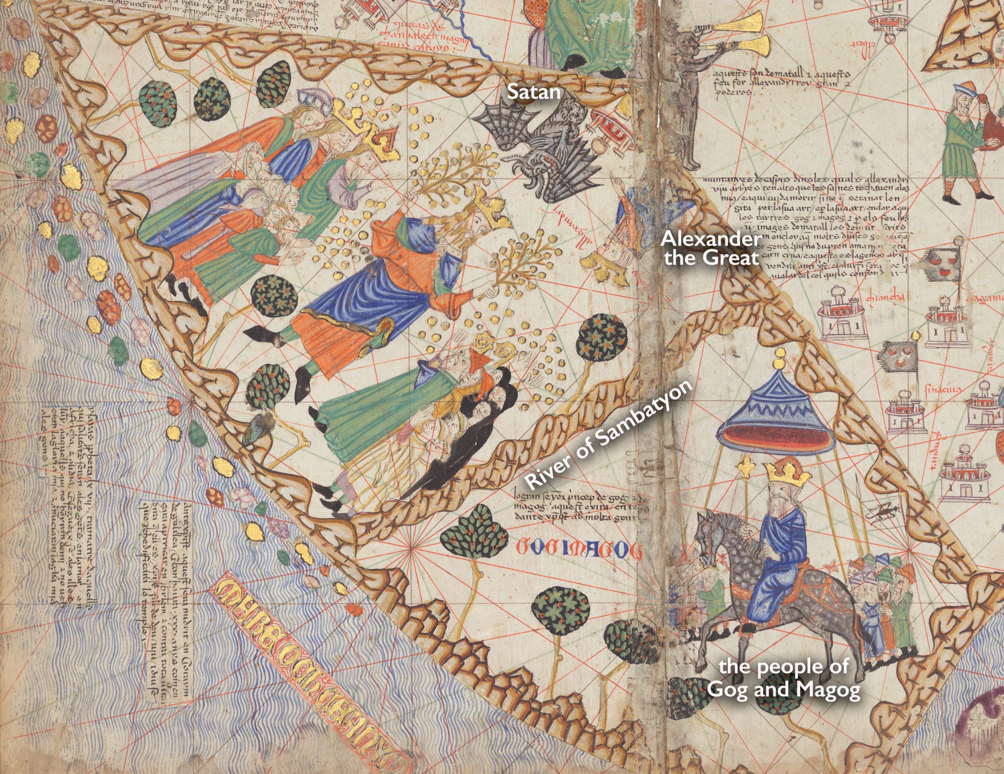
At the far northeastern edge of the Catalan Atlas things really start to get wild.
Firstly, astride a black stallion sits a figure representing the people of Gog and Magog, names which are variously ascribed to individuals, tribes, or lands in the Bible. Whichever version is used, they’re always cast as “very bad men,” often associated with fighting on Satan’s side in the apocalyptic battle of the End Times. There was an old legend that Alexander the Great enclosed these evil people within a ring of mountains, shutting them behind the bronze Caspian Gates. On the map he’s shown calling over the Great Wall of China to enlist the help of Satan himself, perhaps an allusion to the Macedonian’s status as a pagan.
If that wasn’t bad enough, look just below Satan to the kingly figure holding a small shrub in each hand. It’s thought this man is making fruit appear on dry branches, making him no less than… the ANTICHRIST HIMSELF! FLEE, FLEE FOR YOUR LIVES!!! THE BELLS ARE RINGING, THE BELLS ARE RINGING, THE SKY ITSELF IS RINGING!!!

So there you have it. A window into the mind of medieval Europe, where the mundane everyday coexists alongside mythical islands, man-eating birds, and the coming apocalypse.
God, I love old maps.

Purple had represented power, wealth, and royalty ever since Julius Caesar started wearing a purple toga.
The unresolved question of who this King Stephen is really annoys me. There was a King Stephen of England but that wouldn’t make any sense. There’s a Saint Stephen in the Bible but he was stoned to death in Jerusalem, according to Acts of the Apostles, so I’m not sure why he would come to be associated with India. The best I can come up with is Stephen I of Hungary? He was the first of the Magyars to convert to Christianity, and the Magyars came from the east? Maybe? Unless it’s just an entirely made up new King Stephen?
This story comes from Pliny. Until the beginning of the 18th century, pretty much the only known source of diamonds in the entire world was the Golconda region of India. Supposedly, locals threw meat into inaccessible valleys, to which the diamonds would stick. Seeing the meat, eagles would swoop down and gobble it, diamonds and all, and fly off back to their nests, where locals would retrieve the precious stones.
This is, by far, the most beautiful atlas of the XIV century. You can easily take days admiring the cartography and details... and don't get bored!
What a treat! Although medieval manuscripts are my area of expertise, I enjoyed every bit of this post! And I learned something new! Thank you!