

IRAN: PEOPLE OF THE PLATEAU

Welcome to Cosmographia — a newsletter uncovering the deep roots of a turbulent world. For the full map of posts, see here.
This is the second in a series of posts on the history and culture of Iran, one of the world’s great civilisational centres. Read the first here.

There are three great forces that drive human history: geography, technology, and culture. We will begin with geography.
I. MOUNTAIN, DESERT, AND OIL
The vast and jagged expanse of elevated terrain that today we know as the Iranian plateau extends across an area far greater than that enclosed by the borders of the modern nation state of Iran. The platform of dust and rock sweeps southeast from the conjoinment of the Pontic and Taurus Mountains in eastern Anatolia, a region known to antiquity as the Anti-Taurus, through Iraqi Kurdistan, southern Azerbaijan, Iran itself, and eastwards onto Afghanistan, Pakistan, and Turkmenistan. The central plateau averages about a thousand metres above sea level, and was raised upwards aeons ago by two opposing collisions between three of the Earth’s tectonic plates. Along the western and southern edge, the Arabian and Eurasian plates collide to raise the barbed peaks of the Zagros Mountains, while in the east the Eurasian is being shunted in the opposite direction by the Indian plate, raising the deserts of the interior towards skies that never rain as if the land was caught in a vice.
Speaking of deserts, the arid wastelands of the Dasht-e Kavīr and the Dasht-e Lūt that mark the centre of the plateau are surrounded on all sides by a formidable ring of mountains. They are bound in the west by the Zagros; in the north by the Alborz, which themselves rim the edge of the Caspian Sea; in the northeast by the Kopet-Dag Range, which has long provided a porous bulwark against the black sands of the Karakum; in the east by the forbidding Hindu Kush; while to the south the two thousand foot plateau drops off suddenly and without warning into the warm waters of the Persian Gulf. There, the oceanic crust of the Arabian plate that has through its tectonic collision been thrust upwards out of the bowels of the earth has resulted in a region of unfathomable mineral wealth: trillions upon trillions of marine organisms which lived and died in time immemorial are today harvested in the mountainous valleys and watery depths of the Gulf by the billions of barrels. Though these commodities are generally thought of as resources of only recent geopolitical import, from the earliest days of civilisation the Sumerians and Babylonians made use of the thick black bitumen that seeped out of the ground to build their boats and houses.
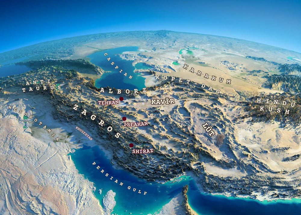
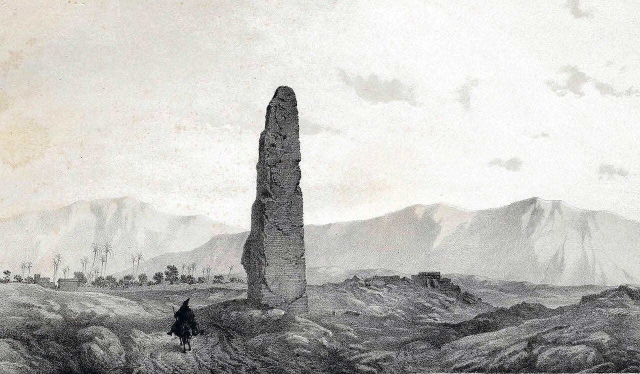
With such hostile topography, civilisation upon the Persian plateau has always formed a ring shape. The bleak wastes of the deserts have for millennia remained largely empty, while the great civilisations of Iran concentrated their cities and monuments in the mountain valleys that encircle the void at their centre. The ancient cities of Elam arose in the lowlands of Khuzestan; the Median kingdom was centred on the western edge of the Alborz; both the Persians and Sassanians originated from the valleys of Persis, at the southeastern edge of the Zagros; while the Parthians first erupted out of the Kopet-Dag highlands.
The ring of mountains and seas that enclose the plateau has long acted as both strength and weakness for the peoples that have found themselves encircled within them. Such challenging geographical barriers have enabled a degree of security over the centuries (though as we shall see, plenty of invading armies have managed to thread their way through the mountain passes) and have played a vital role in maintaining the sense of a distinct Iranian identity over the course of millennia as empires rose and fell about them. The trouble with mountains though, is they make for hard living; where wide, flat plains enable rich agriculture and easy trade access (e.g. Mesopotamia, Nile Valley), narrow mountain passes and poorly connected valleys breed insularity and tribalism, and most were long suitable only for a poor pastoralist lifestyle. Indeed, there is a reason all the great Persian dynasties made sure to conquer the fertile lowlands of Mesopotamia once they had consolidated power over the plateau.
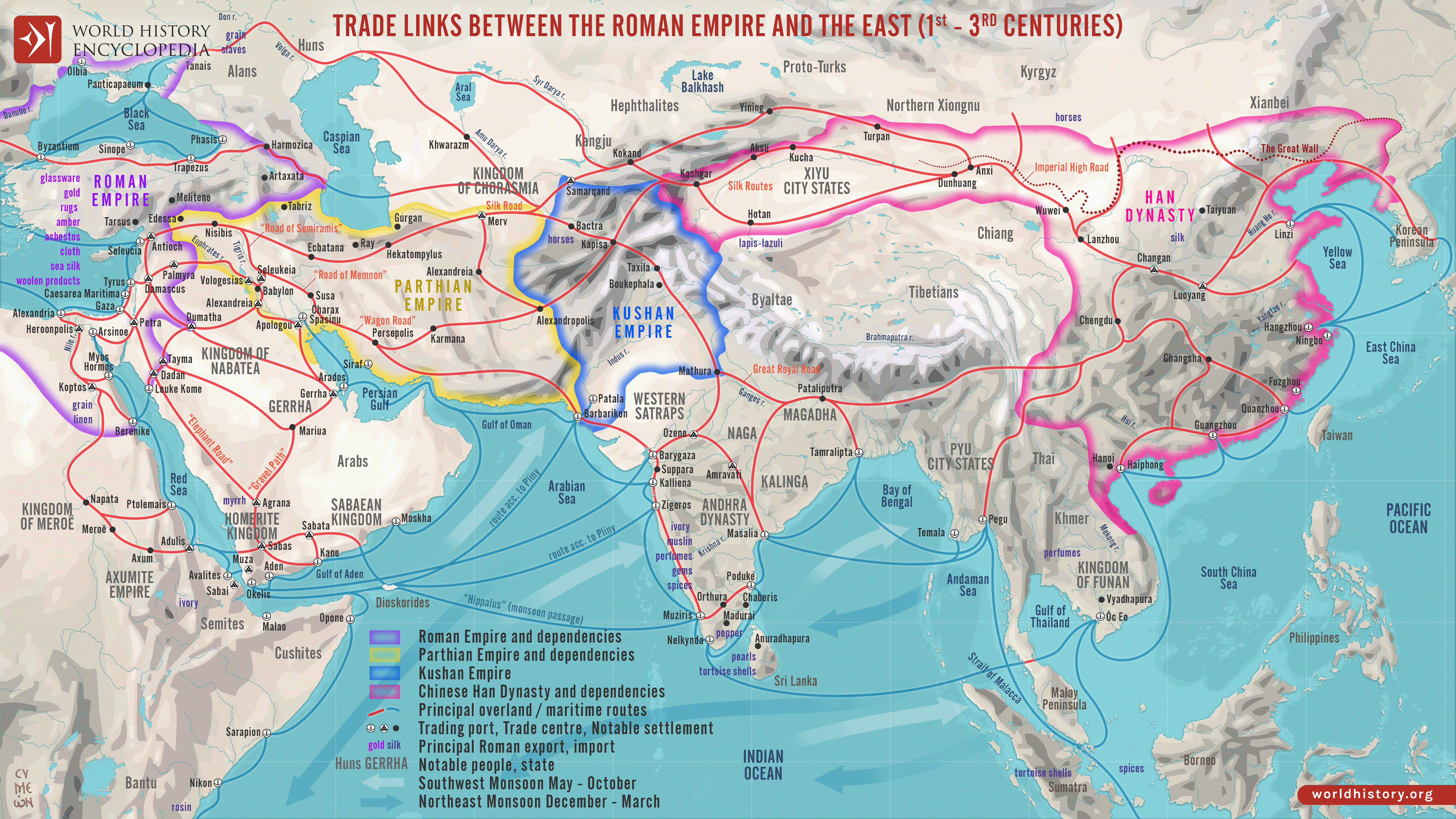
At the same time, however, those same narrow mountain passes acted as great funnels of trade. With the arteries of commerce so narrowly concentrated, an opportunity presents itself to whomsoever can control them. Throughout history, one need not to have conquered the entirety of the plateau to dominate it; instead one needed only to be able to tax the key mountain gateways. This fact was further compounded by Iran’s location at the centre of Eurasia, marking as it does the halfway point between the great civilisations of the East — China, India — and those of the West — Mesopotamia, Egypt, Europe. The Parthian Empire benefited greatly from the trade between Han Dynasty China and the Roman Empire, as did the Abbasid Caliphate between the Tang and Byzantines, and the Mongol-ruled Ilkhanate between mediaeval Europe and the Yuan.
Indeed, Iran still benefits today from its strategic position. The plateau marks the crossways between the Arab, Turkish, Russian, and Indian spheres of influence. And that’s without mentioning its chokehold over the Strait of Hormuz, through which a fifth of the world’s oil and liquified natural gas must pass. By closing the strait in recent days, the Islamic Republic has in affect taken hostage the energy supplies of both Europe and Asia. Beware those who hold the plateau.
II. THE HORSE, THE WHEEL, THE MOTHER OF TONGUES
We turn now to the second great driver of history: technology.
The eighty-six Iranic languages still extant today are a sub-grouping of the more than three hundred Indo-Iranic languages which are themselves the largest branch of the Indo-European language family — a collection of tongues spoken today by 3.2 billion people, some 46% of all people on Earth. One can plot these languages on a chart that resembles an ancestral tree, and like an ancestral tree, one can trace a language back through its ancestral line. The branches of this linguistic tree sweep backwards from the Indian sub-continent, from the shores of the Atlantic Ocean, from the Iranian plateau, from the Central Asian steppe, all the way back to its trunk upon the banks of the lower Dnieper River, in what is now Ukraine.
Around 5000 years ago, a group of people whom archaeologists call the Yamnaya abandoned their farms and their plows upon those black and fertile soils and took instead to the open grassland of the great Eurasian Steppe. They drove before them great herds of sheep, goats, and cattle and pulled behind them wooden wagons that rolled on solid-disc wheels. The Yamnaya themselves were not the inventors of the wheel; instead the most likely candidate (though it’s still intensely disputed) was the Cucuteni-Trypillia culture that preceded them in the lands of Western Ukraine. But the Yamnaya used the technology to expand their horizons in a way thitherto unseen in human history.
